Gyeongbuk Province announced on March 10 that it has completed the first phase of the Intelligent Spatial Information Platform—built to realize a digital platform government and enhance administrative efficiency—and will officially launch the platform’s core provincial property management service.
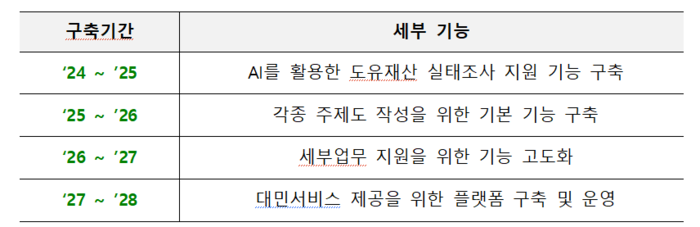
The Intelligent Spatial Information Platform project began with the Information Strategy Plan (ISP) in 2023 and will run through 2027 as a four-year, mid- to long-term initiative. The total project cost is KRW 4,400,007,900 (about $3.3 million). This year, the province will prioritize and deploy an AI-powered support feature for provincial property surveys and provide it to provincial, city, and county staff.
The new platform uses AI to autonomously learn from and analyze aerial imagery and spatial data, automatically flagging anomalies such as unauthorized occupation or illegal land alterations. That allows officials to gather baseline data without traveling to sites, reducing wasted administrative effort and improving transparency in asset management.
Importantly, the platform moves beyond simple map lookups to establish an intelligent decision-support system that integrates administrative data with spatial information. By operating a digital management system that continuously monitors a large inventory of provincial assets, Gyeongbuk can close the blind spots that hindered field surveys amid staffing shortages and build a framework to systematically preserve public asset value.
Gyeongbuk Province plans to expand the platform’s capabilities significantly over the next two years according to a phased roadmap. In 2026 it will add basic tools to create thematic maps that underpin policy-making. In 2027 the province will sequentially roll out targeted administrative supports and public-facing services, including real estate analysis (such as identifying risky jeonse or empty-deposit leases), site analysis (earthwork volumes and slope), and permit analysis (regulation checks).
Park Jong-tae, director of Gyeongbuk’s Construction and Urban Affairs Bureau, said, “The Intelligent Spatial Information Platform is a core model of digital transformation that embeds advanced artificial intelligence into everyday administrative work. We will complete the planned upgrades through 2027 on schedule and provide residents with more convenient, transparent, data-driven services.”
Jeong Jae-hoon, reporter jhoon@etnews.com